简介
本文介绍使用matlab对遥感图像软件上截取的tiff格式图像进行图像提取和地理位置的提取。简单介绍matlab所使用的对应类和函数:geotiffread函数,GeographicCellsReference类,intrinsicToGeographic函数。最后使用matlab提供的相关函数提取每个像素的地理坐标转换为点云数据。
主要函数与类介绍
1,[A,R] = geotiffread(filename)
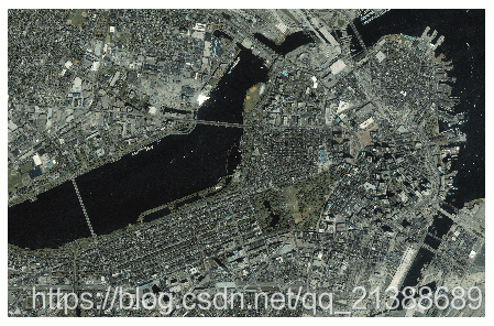
从由filename 指定的GeoTIFF文件中读取地理灰度图,RGB或多光谱图像或数据网格到A 中,并创建GeographicCellsReference对象R。 [boston,R] = geotiffread('boston.tif'); figure mapshow(boston,R); axis image off
图像的显示结果如下:
2,[X,cmap,R] = geotiffread(filename)
[A,refmat,bbox] = geotiffread(filename)
[X,cmap,refmat,bbox] = geotiffread(filename)
以上函数功能和第一个差不多,详情见matlab对函数geotiffread的说明:http://www.mathworks.com/help/map/ref/geotiffread.html
3,Geogr
最后
以上就是秀丽发卡最近收集整理的关于matlab 读取pts_matlab读取tiff卫星遥感图像和地理信息并转化为点云的全部内容,更多相关matlab内容请搜索靠谱客的其他文章。
本图文内容来源于网友提供,作为学习参考使用,或来自网络收集整理,版权属于原作者所有。
![[Math]简单产生白噪声的算法](https://www.shuijiaxian.com/files_image/reation/bcimg26.png)


发表评论 取消回复