一、mybatis+pgsql的xml
下面统计的sql中用到的聚合函数具体解析说明:
第一部分
array_to_string( ARRAY_AGG ( stp.source_server ), ',' ): 将stp的source_server的数据转化为数组,再以逗号分隔拼接起来转成字符串。
array_to_string( ARRAY_AGG ( stp.target_server ), ',' )将stp的target_server的数据转化为数组,再将数组转换为字符串,用“,”分隔。(有点类似于Mysql的group_concat()函数)concat_ws ( ',', 'a', 'b' ):将ab以逗号连接。在下面的案例中:concat_ws ( ',', array_to_string( ARRAY_AGG ( stp.source_server ), ',' ), array_to_string( ARRAY_AGG ( stp.target_server ), ',' ) )是将第一步的两个结果,合并成一个字符串regexp_split_to_table((a,b),',' ):将a,b以逗号分隔开并将a、b分别作为表查询的结果。在下面的案例中,regexp_split_to_table( ( concat_ws ( ',', array_to_string( ARRAY_AGG ( stp.source_server ), ',' ), array_to_string( ARRAY_AGG ( stp.target_server ), ',' ) ) ), ',' )将第二步的结果,以逗号“,”分隔,并把每一项作为结果DISTINCT将第三步的结果去重COUNT ( * )统计第四步去重后的数量
第二部分
SUM ( stad.data_volume ),计算data_volume的和ROUND( '100' :: NUMERIC / 10, 3 )将100除以10后保留小数点后三位。其中:: NUMERIC将字符串’100’转为数字(numeric类型最多能存储有1000个数字位的数字并且能进行准确的数值计算。它主要用于需要准确地表示数字的场合,如货币金额。不过,对numeric 类型进行算术运算比整数类型和浮点类型要慢很多。)。案例中ROUND( SUM ( stad.data_volume ) :: NUMERIC / ( 1024 * 1024 * 1024 ), 3 )将第一步的结果转为字符串并除以1024的三次方(将字节B转–>kb–>mb–>GB)CAST(oti.institution_id AS VARCHAR)将int型institution_id转为varchar型- 将时间字段格式化为指定格式
to_char(create_time,'yyyy-mm-dd')
mybatis+postgresql写原生sql,不用xml
@Select({"${sqlStr}"})
    @Results({
            @Result(column = "gid", property = "gid", jdbcType = JdbcType.INTEGER, id = true),
            @Result(column = "name", property = "name", jdbcType = JdbcType.VARCHAR),
            @Result(column = "geom", property = "geom", jdbcType = JdbcType.VARCHAR),
            @Result(column = "code", property = "code", jdbcType = JdbcType.VARCHAR)
    })
    List<ModelPolygon> exeNativeSql(@Param("sqlStr") String sqlStr);


    @Select({"${sqlStr}"})
    List<ModelPolygon> exeNativeSql(@Param("sqlStr") String sqlStr);
    //"select gid as gid,name as name,ST_AsGeoJson(geom) as geom,code as code from wl_model_polygon"
整个dao层的写法:
package com.xxx.mapper;

import com.alibaba.fastjson.JSONObject;
import com.baomidou.mybatisplus.core.mapper.BaseMapper;
import com.xxx.entity.UserInfo;
import org.apache.ibatis.annotations.*;
import org.apache.ibatis.type.JdbcType;

import java.util.List;

@Mapper
public interface UserInfoMapper extends BaseMapper<UserInfo> {

    @Select({"${sqlStr}"})
    @Results({
            @Result(column = "id", property = "id", jdbcType = JdbcType.VARCHAR, id = true),
            @Result(column = "username", property = "username", jdbcType = JdbcType.VARCHAR),
            @Result(column = "email", property = "email", jdbcType = JdbcType.VARCHAR),
            @Result(column = "phone", property = "phone", jdbcType = JdbcType.VARCHAR),
            @Result(column = "password", property = "password", jdbcType = JdbcType.VARCHAR),
            @Result(column = "true_name", property = "trueName", jdbcType = JdbcType.VARCHAR),
            @Result(column = "usetime", property = "usetime", jdbcType = JdbcType.VARCHAR)
    })
    List<UserInfo> exeNativeQuerySql(@Param("sqlStr") String sqlStr);

    @Select({"${sqlStr}"})
    List<JSONObject> exeNativeExecSql(@Param("sqlStr") String sqlStr);
}
 <!--数据量统计  -->
    <select id="getDataByParams" resultType="com.htht.datatrans.app.vo.CountProtocolVO">
		SELECT
			*
		FROM
			(
			SELECT COUNT
				( * ) AS useNode
			FROM
				(
				SELECT DISTINCT
					regexp_split_to_table(
						(
							concat_ws ( ',', array_to_string( ARRAY_AGG ( stp.source_server ), ',' ), array_to_string( ARRAY_AGG ( stp.target_server ), ',' ) )
						),
						','
					)
				FROM
					sync_t_protocol AS stp
				WHERE
					stp.deleted = 0
					AND stp.protocol_type = 'data communication'
				) res
			) node1,
			(
			SELECT COUNT
				( * ) AS runningNode
			FROM
				(
				SELECT DISTINCT
					regexp_split_to_table(
						(
							concat_ws ( ',', array_to_string( ARRAY_AGG ( stp.source_server ), ',' ), array_to_string( ARRAY_AGG ( stp.target_server ), ',' ) )
						),
						','
					)
				FROM
					sync_t_protocol AS stp
				WHERE
					stp.deleted = 0
					AND stp.protocol_type = 'data communication'
					AND stp.run_state = 'running'
				) res
			) node2,
			( SELECT COUNT ( * ) AS protocolTotal FROM sync_t_protocol AS stp WHERE stp.deleted = 0 AND stp.protocol_type = 'data communication' ) protocol1,
			(
			SELECT COUNT
				( * ) AS runningProtocol
			FROM
				sync_t_protocol AS stp
			WHERE
				stp.deleted = 0
				AND stp.protocol_type = 'data communication'
				AND stp.run_state = 'running'
			) protocol2,
			(
			SELECT COUNT
				( * ) AS exceptionalProtocol
			FROM
				sync_t_protocol AS stp
			WHERE
				stp.deleted = 0
				AND stp.protocol_type = 'data communication'
				AND stp.run_state = 'exception'
			) protocol3,
			(
			SELECT
				ROUND( SUM ( stad.data_volume ) :: NUMERIC / ( 1024 * 1024 * 1024 ), 3 ) AS runningData
			FROM
				sync_t_action_detail AS stad
				INNER JOIN sync_t_protocol AS stp ON stad.protocol_id = stp.protocol_id
				AND stp.deleted = 0
				AND protocol_type = 'data communication'
			WHERE
				stad.execute_state = ANY ( STRING_TO_ARRAY( 'running', ',' ) )
			) data1,
			(
			SELECT
				ROUND( SUM ( stad.data_volume ) :: NUMERIC / ( 1024 * 1024 * 1024 ), 3 ) AS historyData
			FROM
				sync_t_action_detail AS stad
				INNER JOIN sync_t_protocol AS stp ON stad.protocol_id = stp.protocol_id
				AND stp.deleted = 0
				AND protocol_type = 'data communication'
			WHERE
			stad.execute_state = ANY ( STRING_TO_ARRAY( 'succeed,failed', ',' ) )
			) data2
	</select>

<select
		id="getPagesByParams"
		resultType="com.htht.datatrans.app.vo.CloudVO">
		select * from ops_t_cloud where delete=0
		<if test="cloudProvider != null and cloudProvider != ''">
			and cloud_provider like '%'||#{cloudProvider,jdbcType=VARCHAR}||'%'
		</if>
		order by cloud_id
	</select>

<select
		id="getByCloudCodes"
		resultType="com.htht.datatrans.app.entity.Cloud">
		select * from ops_t_cloud where delete=0
		<if test="cloudCodes != null and cloudCodes != ''">
			and cloud_code = ANY(STRING_TO_ARRAY(#{cloudCodes,jdbcType=VARCHAR}, ','))
		</if>
		order by cloud_id
	</select>
	<select
		id="getPagesByParams"
		resultType="org.springblade.modules.datatrans.vo.ServerPageVO">
		select ots.*,otc.cloud_name as cloudName,otc.domain_name as domainName
		from ops_t_server ots
		inner join ops_t_cloud otc on ots.cloud_id = otc.cloud_id
		<if test="institutionId != null and institutionId != ''">
			inner join ops_t_institution oti ON CAST(oti.institution_id AS VARCHAR) = ots.institution_id
		</if>
		where ots.deleted=0
		<if test="cloudProvider != null and cloudProvider != ''">
			and otc.cloud_provider like concat(concat('%',#{cloudProvider,jdbcType=VARCHAR}),'%')
		</if>
		order by ots.server_id
	</select>
二、字符串替换
将address字段里的 “区” 替换为 “呕” 显示,如下
select *,replace(address,'区','呕') AS rep
from test_tb

将name字段里的 “我” 替换为 “你” 保存,如下
UPDATE blade_visual
SET "name" = ( REPLACE ( NAME, '你', '你们三' ) )
三、postgre做空间数据分析
比如面相交
1、使用步骤
- 新建空间索引create extension postgis;
- 创建geometry类型字段

3.插入geometry数据
insert into wl_model_polygon(geom,name,code) values ('SRID=4326;POLYGON ((116.2078857421875 39.928694653732364, 116.20925903320312 39.91078961774283, 116.20651245117188 39.89393354266699, 116.23397827148436 39.86547951378614, 116.24496459960938 39.82752244475985, 116.29852294921876 39.78954439311165, 116.3397216796875 39.78532331459258, 116.3836669921875 39.78848914776114, 116.41799926757811 39.79904087286648, 116.444091796875 39.80748108746673, 116.45919799804688 39.818029898770206, 116.48117065429686 39.83490462943255, 116.50314331054688 39.86231722624386, 116.50588989257812 39.88023492849342, 116.5045166015625 39.90973623453719, 116.4935302734375 39.925535281697286, 116.5045166015625 39.94975340768179, 116.47979736328125 39.98132938627215, 116.47567749023438 39.99395569397331, 116.45507812500001 40.000267972646796, 116.43859863281249 40.000267972646796, 116.4166259765625 39.998163944585805, 116.36581420898438 40.00868343656941, 116.35208129882812 40.00447583427404, 116.30264282226562 40.01078714046552, 116.27792358398436 39.999215966720165, 116.24771118164061 39.99500778093748, 116.23260498046874 39.990799335838034, 116.21200561523438 39.95606977009003, 116.2078857421875 39.928694653732364))
','产流区单元','1');

insert into wl_model_polygon(geom,name) values ('SRID=4326;POLYGON ((118.76382985390228 30.94145000894207, 118.76367454479498 30.941584547525736, 118.76350796485406 30.941783659824637, 118.76339844820404 30.941924731032316, 118.76330916107543 30.942036894992782, 118.76327040751187 30.94208876002824, 118.76320401397413 30.942103072784164, 118.76311833308432 30.942151844969032, 118.76297412628924 30.94233241273298, 118.76284033474406 30.942507490217793, 118.76274061465483 30.942508998759877, 118.76272709824036 30.942414705157432, 118.76260312963427 30.941400575247428, 118.76246246134042 30.940958834692708, 118.76241983918237 30.940824987759868, 118.76235477020532 30.94068130925791, 118.76232222882629 30.940647540114867, 118.76293788696353 30.940087796711964, 118.76307156743417 30.939971500356137, 118.76327063857775 30.93979831612114, 118.7635558539929 30.939541452438277, 118.7637265129556 30.93939848398361, 118.76377770256443 30.939355600092142, 118.76441910672565 30.9388159785355, 118.76463064154075 30.938667159236218, 118.76495341070222 30.938493604345012, 118.76523672506141 30.938409477348614, 118.7654197381786 30.9383707434975, 118.76582985307277 30.938323591604444, 118.76622053407164 30.9382963001612, 118.76643330279228 30.938318107809664, 118.7664801815057 30.938337017341382, 118.76652477352764 30.938350675989682, 118.7666582796586 30.938456597505137, 118.76673673369658 30.938603248874927, 118.76677236100761 30.938782266531803, 118.76684549711081 30.939149764149192, 118.76701632885761 30.93988929949859, 118.7670376347395 30.939981532336844, 118.7664187768753 30.94010020307178, 118.76614981686157 30.940150404326346, 118.7658940991671 30.940243370814187, 118.76569247579346 30.940342755588517, 118.76556089310861 30.940412552128976, 118.76552036966268 30.940466789099446, 118.76550573912039 30.940574355758315, 118.76551217968313 30.941150469586262, 118.76551098575817 30.941290908017095, 118.76550989936004 30.941418699044846, 118.76542260756776 30.94141695016964, 118.76499121731501 30.941408306476433, 118.76391937007008 30.94138581330907, 118.76382985390228 30.94145000894207))','产流区单元');
- pg库清空数据和主键自增
TRUNCATE TABLE wl_model_polygon;

TRUNCATE wl_model_polygon RESTART IDENTITY;
- 相交分析sql
select gid,name,ST_AsGeoJson(geom) as geom from wl_model_polygon t where ST_Intersects(t.geom,ST_GeomFromGeoJSON('{"type":"Polygon","coordinates":[[[118.78355107920095,30.938155072659868],[118.78134774048146,30.939763084116294],[118.7812957819458,30.93972376187253],[118.78286595934765,30.93838280705404],[118.7833158576293,30.93793078253492],[118.78355013577584,30.938153972966006],[118.78355107920095,30.938155072659868]]]}
'))

select gid,name,ST_AsGeoJson(geom) as geom from wl_model_polygon t where ST_Intersects(t.geom,ST_GeomFromGeoJSON('{"type":"Polygon","coordinates":[[[118.78355107920095,30.938155072659868],[118.78134774048146,30.939763084116294],[118.7812957819458,30.93972376187253],[118.78286595934765,30.93838280705404],[118.7833158576293,30.93793078253492],[118.78355013577584,30.938153972966006],[118.78355107920095,30.938155072659868]]]}'))
四、自增序列
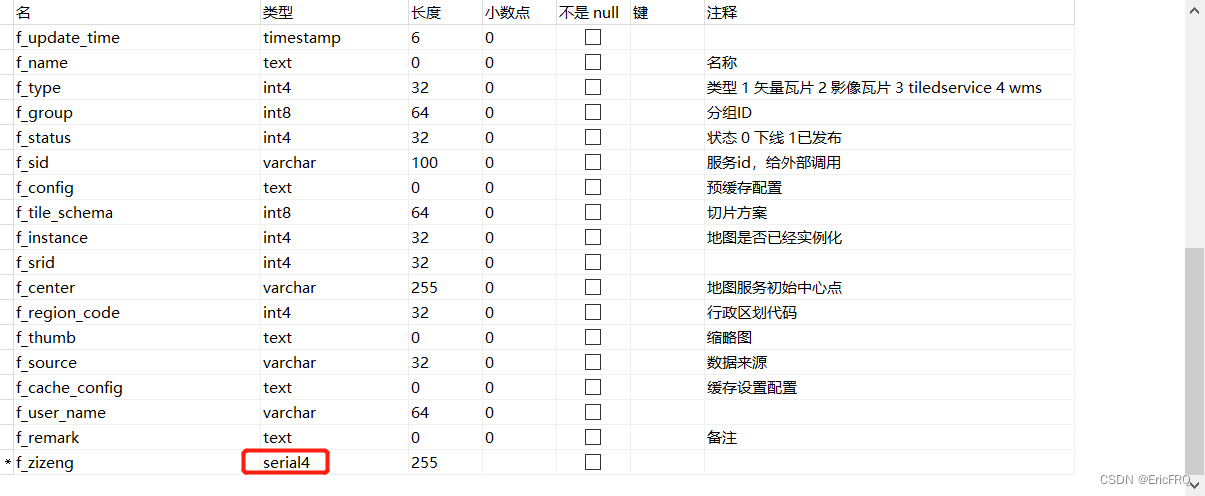
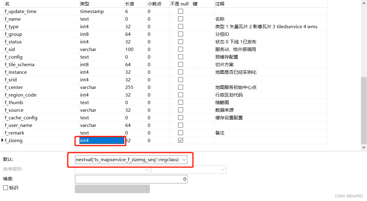
1、navicat创建自增字段
设置为serial4类型

保存后自动加序列

2、重置自增序列号为指定数值
第一步:select pg_get_serial_sequence('ts_mapservice', 'f_remark');查看序列为public.ts_mapservice_f_remark_seq
第二步:更新序列值ALTER SEQUENCE public.ts_mapservice_f_remark_seq RESTART WITH 8;
或者直接初始化自增数值:TRUNCATE TABLE wl_model_polygon; TRUNCATE wl_model_polygon RESTART IDENTITY;
最后
以上就是悲凉音响最近收集整理的关于pgsql个人笔记一、mybatis+pgsql的xml二、字符串替换三、postgre做空间数据分析四、自增序列的全部内容,更多相关pgsql个人笔记一、mybatis+pgsql内容请搜索靠谱客的其他文章。
本图文内容来源于网友提供,作为学习参考使用,或来自网络收集整理,版权属于原作者所有。


发表评论 取消回复