Landsat-8
Bands
| 波段名称 | 波长(微米) | 空间分辨率 |
|---|---|---|
| Band 1 – coastal aerosol | 0.43–0.45 | 30 |
| Band 2 - blue | 0.45–0.51 | 30 |
| Band 3 - green | 0.53–0.59 | 30 |
| Band 4 - red | 0.64–0.67 | 30 |
| Band 5 - near infrared (NIR) | 0.85–0.88 | 30 |
| Band 6 - SWIR 1 | 1.57–1.65 | 30 |
| Band 7 - SWIR 2 | 2.11–2.29 | 30 |
| Band 8 - panchromatic | 0.50–0.68 | 15 |
| Band 9 - cirrus | 1.36–1.38 | 30 |
| Band 10 - Thermal Infrared 1 | 10.60–11.19 | 100 |
| Band 11 - Thermal Infrared 2 | 11.50–12.51 | 100 |
Band 8是全色波段(Panchromatic band)。因为是单波段,在图上显示是灰度图片。全色遥感影像一般空间分辨率高,但无法显示地物色彩。 实际操作中,我们经常将之与其它波段影象融合处理,得到既有全色影象的高分辨率,又有其它波段影象的彩色信息的影象。
IKONOS Stereo Satellite Imagery
Reference stereo products have a horizontal accuracy of 25 meters CE90 and a vertical accuracy of 22 meters LE90 without any Ground Control Points (GCP’s). When reliable GPS derived GCP photo ID control is available for the area to be collected the horizontal and vertical Geospatial accuracy increases to <2.5m horizontal and <1.5m vertical.
IKONOS stereo satellite images have the potential for creating DSM/DEM’s. The primary advantage of stereo imagery is the ability to extract vector features and geographic features in 3D such as buildings, roads, manmade structures and other terrain features. This accuracy can be consistently achieved with terrain slope conditions of <20%.
Stereo satellite imagery is especially important for global markets where accurate elevation data is not readily available. Many commercial markets will benefit from stereo imagery and 3D Digital Terrain Models including mapping for oil and gas exploration, mining, engineering and construction, environmental, urban planning, agriculture and forestry.
The three main attributes of IKONOS stereo imagery are 360-degree pointing capability, a base-to-height (B/H) ratio of 0.6 and greater - similar in scope to aerial photography. Stereo products can be produced in either epipolar or map projection and can be acquired at most areas of the World.
IKONOS Satellite Sensor Characteristics
| Launch Date | 24 September 1999 at Vandenberg Air Force Base, California, USA |
|---|---|
| Operational Life | Over 7 years |
| Orbit | 98.1 degree, sun synchronous |
| Speed on Orbit | 7.5 kilometers per second |
| Speed Over the Ground | 6.8 kilometers per second |
| Revolutions Around the Earth | 14.7, every 24 hours |
| Altitude | 681 kilometers |
| Resolution at Nadir | 0.82 meters panchromatic; 3.28 meters multispectral |
| Resolution 26° Off-Nadir | 1.0 meter panchromatic; 4.0 meters multispectral |
| Image Swath | 11.3 kilometers at nadir; 13.8 kilometers at 26° off-nadir |
| Equator Crossing Time | Nominally 10:30 AM solar time |
| Revisit Time | Approximately 3 days at 40° latitude |
| Dynamic Range | 11-bits per pixel |
| Image Bands | Panchromatic, blue, green, red, near IR |
Bands
Panchromatic at 0.82 meter at Nadir
526 - 928 nm (Pan)
Multispectral at 3.28 meter at Nadir
Blue, Green, Red, and NIR.
445 - 516 nm (Blue)
506 - 595 nm (Green)
632 - 698 nm (Red)
757 - 853 nm (NIR)
Projections
Map projected stereo products offer a choice of UTM, TM, State Plane, Lambert Conformal Conic products are produced in NITF or GeoTIFF format.
Resolution
0.8 to 1.0 meter resolution (Pansharpened). Resolution depends on the collection geometry of the satellite sensor when image data is acquired.
Sun Angle
Elevation angle from ground to sun > 15°, azimuth unrestricted.
Sensor Elevation
Sensor elevation angle > 72° for one image and > 60° for the other.
Cloud Cover
Less than or equal to 15 % Cloud Cover per AOI
Sentinel-2
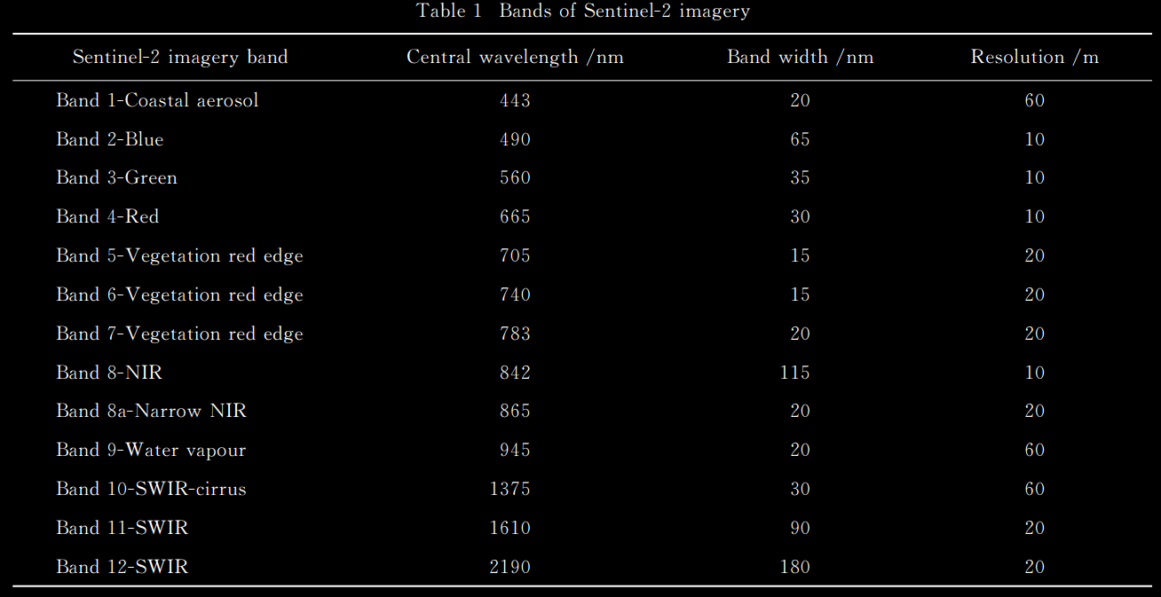
Sentinel-2环境监测卫星是欧盟委员会(EC)和欧洲航天局(ESA)共同倡议的全球环境与安全监测系统“哥白尼计划”中的第二颗卫星. Sentinel-2A和Sentinel-2B分别于2015年6月和2017年3月成功发射. Sentinel-2卫星的主要任务是对全球陆地表面进行高分辨率多光谱成像. 该卫星的轨道高度为786km, 观 测 幅 宽 为 290km, 使 用 寿 命 为7.25a, 单星重访周期为10天, A/B 双星重访周期为5天. 卫星上搭载了一个采用推扫式成像模式的多光 谱 成 像 仪 (MSI), 且 包 含 一 个 光 瞳 直 径 为150mm的望远镜,该望远镜的结构和反射镜利用碳化硅材料制成,可减少光学系统的热变形. 该卫星影像共有13个波段,空间分辨率分别为10, 20, 60m,各波段空间分辨率的详细情况如下表所示.
Sentinel-2发布的数据为已经进行过几何校正和辐射校正的大气上层表观反射率产品,所以只需对该数据进行大气校正即可。采用ESA官方提供的SNAP软件对下载的数据进行大气校正。
最后
以上就是悦耳黄豆最近收集整理的关于various satellit based remote sensingLandsat-8IKONOS Stereo Satellite ImagerySentinel-2的全部内容,更多相关various内容请搜索靠谱客的其他文章。


发表评论 取消回复